• Home
    • Identities: Latin American Folkloric dance in London
    • Haitians in the Dominican Republic
    • Uvero Alto Part 1: Archive
    • Uvero Alto Part 2: 2007-2014
    • Sahrawis,The wall of shame
    • El Ausente
    • Latin Americans in London
    • Walking around
    • Nueva Generacion
    • Printmaking
    • Chagossians claiming their land
    • India
    • Truth, Memory and Reconciliation Commission of Colombian Women
    • La Siembra de la Vida
    • Peacebuilding in Liberia - Conciliation Resource
    • USIP/Build Up: CAR
    • Participatory Photography & Video
    • Latin Elephant
    • Events
    • Unicef
    • Portraits
    • The Carnaval del Pueblo
    • Migrants NGO
  • Tearsheets
  • Exhibitions
  • About me
  • Contact
  • Blog
Menu

Ingrid Guyon

Photographer & Filmmaker | London & Barcelona
  • Home
  • Projects
    • Identities: Latin American Folkloric dance in London
    • Haitians in the Dominican Republic
    • Uvero Alto Part 1: Archive
    • Uvero Alto Part 2: 2007-2014
    • Sahrawis,The wall of shame
    • El Ausente
    • Latin Americans in London
    • Walking around
    • Nueva Generacion
    • Printmaking
    • Chagossians claiming their land
    • India
  • Commissions
    • Truth, Memory and Reconciliation Commission of Colombian Women
    • La Siembra de la Vida
    • Peacebuilding in Liberia - Conciliation Resource
    • USIP/Build Up: CAR
    • Participatory Photography & Video
    • Latin Elephant
    • Events
    • Unicef
    • Portraits
    • The Carnaval del Pueblo
    • Migrants NGO
  • Tearsheets
  • Exhibitions
  • About me
  • Contact
  • Blog

Shortlisted for the Compas Visual Arts Competition!

November 16, 2014

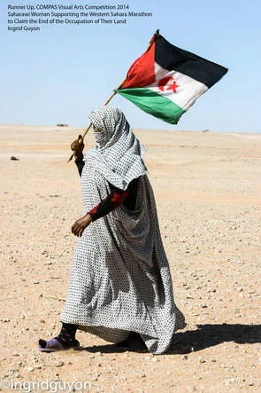
I am delighted to have been shortlisted for the Compas Visual Arts Competition depicting the experience of migration in Sahrawis in the occupied Western Sahara.

The berm.The Moroccan Wall of Western Sahara is an approximately 2,700 km-long structure, mostly a sand wall (or "berm"), running through Western Sahara and the southeastern portion of Morocco. It separates the Moroccan-controlled areas (Southern Provinces) and the Polisario-controlled Free Zone (nominally Sahrawi Arab Democratic Republic) that lies along its eastern and southern border.

Known as ‘the Berm’, the wall was constructed by the Moroccans from sand and stone to keep the Polisario Front, the Western Sahara liberation movement, out of the territory and prevent the 165,000 Saharawi refugees from returning to their land. Standing at around 3 metres in height, the wall runs through the desert and is fortified with barbed-wire fencing, artillery posts and one of the highest densities of land mines in the world. - See more information here and on my .

← London’s Latin Quarter is Here!Walking around with my Yashica →